Flanders Environment Agency improves air quality policy with a smart mapping app.


Flanders Environment Agency takes air quality policy to the next level with a smart mapping app
Air quality is a priority for cities and municipalities, but how do you quickly gain insight into complex data? VMM was looking for a solution to support local authorities with a user-friendly tool. The result: a powerful mapping application that makes analyses easier and faster.
The Challenge – Fragmented Data Slows Down Local Policy
How can you improve air quality in cities and municipalities without getting lost in a maze of data? The Flanders Environment Agency (VMM) noticed that local authorities had access to the necessary information, but struggled to analyze it efficiently and identify connections. “A central, accessible solution was missing, causing policymakers to lose valuable time analyzing complex datasets,” says Maarten Peeters, Coordinator of “Together for Clean Air” at VMM.
The Solution – An Intuitive Mapping Application as a Gamechanger
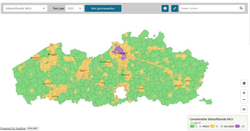
Together with Cegeka, GIM developed a mapping application that displays air quality data in a clear and interactive way. The foundation? Geoblox, GIM’s powerful framework known for its speed and stability. But it didn’t stop there: GIM built custom features, enabling users to filter data, discover trends, and uncover patterns. Moreover, VMM can easily add new data and adjust configurations themselves, without relying on external developers.
The Result – Faster Insights, Better Policy
Thanks to the local air quality screening tool, local authorities can now identify air quality issues and set priorities in just half a day. The new tool presents data in a visually appealing and dynamic way, enabling municipalities to quickly understand the impact of sectors and emissions.
Collaboration is also easier: analyses can be shared, exported, and revisited, allowing different teams to work together on well-considered policy measures.
“With this smart GIS solution, VMM makes air quality a clear priority, without policymakers having to navigate a fog of data. The collaboration between VMM, GIM, and Cegeka also went smoothly throughout the project, with short communication lines and a pragmatic approach,” concludes Maarten.